[spacer height=”1px”]
To help Council Candidates and Voters better understand cycling policy and infrastructure project priorities, Bike Winnipeg has put together a number of policy and infrastructure recommendations that we hope can be moved forward in the next term of council.
Local Priorities for Walking and Biking
The University of Manitoba’s Fort Garry Campus is the second most visited destination in the City of Winnipeg. Only the downtown attracts more trips than the Fort Garry Campus. If we want to get more people biking more often in the City of Winnipeg, our planning will have to consider ways to get people biking to the U of M’s Fort Garry Campus.
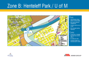 Areas of concern with the Henteleff Park site revolved around the potential for disturbance of the natural setting through increased foot traffic, the creation of a “pipeline effect” through the park site which might detract from its natural setting, and increased parking demand around the park and in the residential area south of Henteleff Park (Van Hull Estates). These are legitimate concerns, but we should be able to mitigate against these effects. What’s needed now is a collaborative approach that can develop designs and policies that address these concerns while providing this much needed link to the University of Manitoba.
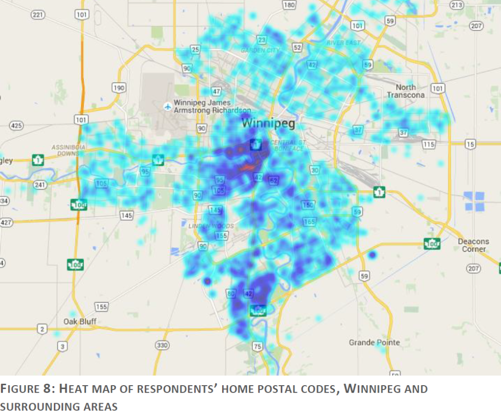
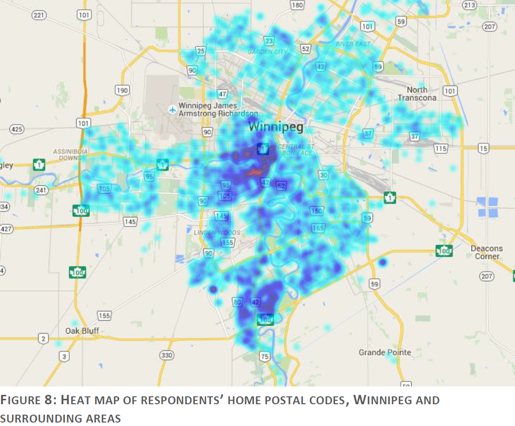
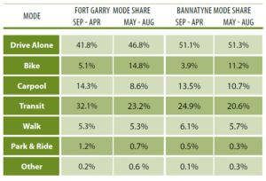 A 2016 Transportation Survey of Students, Faculty, and Staff showed that almost 15% of people commuting to the campus do so on bike during the spring semester (May – August), dropping to a little more than 5% of trips in the fall semester (September – April). So a lot of people are already biking to the campus, but the study also shows that a lot more people would like to bike to the Fort Garry Campus.
 More Information
St. Vital /U of M Red River Crossing Study
The lack of connectivity between the Fort Garry Campus and St. Vital was the subject of a 2012/2013 study commissioned by the city to look into potential locations for a walking/biking crossing of the Red River linking St. Vital to the U of M. The study looked at five potential crossing locations, and even looked at the potential of a gondola to provide the crossing. Two areas were identified for further study, a crossing site near St. Amant Centre, and a crossing site at the west end of Henteleff Park. The Henteleff Park site received the highest evaluation score in the study. It was also the site most preferred by online survey and open house exit poll respondents, receiving nearly twice as many votes as any other site. Analysis by Bike Winnipeg at the time of the study also showed the Henteleff Park site to be the most farourable crossing location.
a 2012/2013 Study of potential crossing sites for a walk/bike bridge between the U of M and St. Vital selected the Hentelff Park Crossing Zone as the best site for a walk/bike bridge.
2016 U of M Transportation Study Shows Strong Desire to Bike to Campus
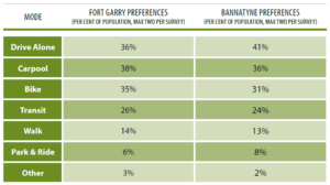
35% of those surveyed identified biking as one of two ideal ways to get to the Fort Garry Campus. Cycling as a commuting mode exhibited the largest difference between actual mode share and interest in the mode under ideal circumstances, with 35% of Fort Garry respondents expressing interest in cycling to campus.
When considering only those respondents who said they drove alone to the Fort Garry campus between 20% and 100% of the time, 41% of surveyed students identified biking as one of their two most preferred ways to get to the campus under ideal circumstances. For faculty, U of M staff, and non U of M staff, only continuing to drive alone was chosen more often than biking as one of their two preferred ways to get to campus under ideal circumstances.
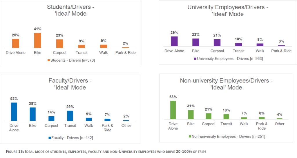 55% of respondents identified improved cycling infrastructure as an important or very important influence on the mode of transport chosen to reach the Fort Garry Campus (Table 10, pg. 26). Clearly, there is a substantial latent demand to bike to campus among people commuting to the Fort Garry Campus that can be tapped into if we provide the infrastructure needed to make their ride safe, comfortable, and convenient.
A Walk/Bike Bridge between South St. Vital and the U of M’s Fort Garry Campus through Henteleff Park would provide access to the campus from an area of town with a growing student population that is currently not well served by the city’s cycling network.
2016 survey results show a substantial number of students, faculty, and staff commute to the U of M’s Fort Garry campus from South St. Vital and would benefit from the construction of a walk/bike bridge connecting the campus to South St. Vital through Henteleff Park
- Conceptual Design Study – St. Vital/U of M Red River Crossing (City of Winnipeg)
- Note: You will need to skip a number of pages at the start of the document to get to the report.
- 2013 St. Vital/U of M Red River Crossing Backgrounder (Bike Winnipeg)
- 2016 U of M Transportation Survey Results & Recommendations Final Report (University of Manitoba)
- University of Manitoba Pedestrian and Cycling Plan (University of Manitoba)
Since 2008, the City of Winnipeg has been installing buffered bike lanes along Pembina Highway as part of routine rehabilitation work on the roadway funded through the Regional Street Renewals Program. To date, sections of buffered bike lane have been installed (or are being installed) along the following stretches of Pembina Hwy:
- Jessie Ave to Grant Ave (scheduled for completion in 2019)
- Harrow St to Point Road (as part of the Pembina Underpass Rehabilitation project)
- Chevrier Ave/Crescent Dr to Plaza Dr
- University Cr to Markham Rd
- Chancellor Matheson Rd to Dalhousie Dr/Bairdmore Blvd
- Bairdmore Blvd/Dalhousie Dr to De Vos Rd
- De Vos Rd to Cloutier Dr (shared use path beneath the South Perimeter Highway Overpass)
- Cloutier Dr to South of Ducharme Ave
The city has been installing buffered bike lanes on Pembina Hwy since 2008 as part of routine roadway rehabilitation work.
The addition of buffered (or preferably protected) bike lanes on Pembina Hwy is backed key recommendations in the Complete Communities Policy Document[1] and Pedestrian and Cycling Strategies[2].
Current forecasts of rehabilitation work in the Regional Streets Renewal Program and Accelerated Regional Streets Renewal Program call for rehabilitation work on the following stretches of Pembina Hwy:
- Des Trappistes to Ducharme Ave (2021)
- McGillivray Ave to Chevrier Ave (2022)
- Pembina Hwy Overpass (2022 & 2023)
That will leave gaps in the buffered/protected bike lanes along the following stretches of Pembina Hwy:
- Grant Ave to Harrow St
- Point Rd to McGillivray Ave
- Plaza Dr to University Cr (should be included in Pembina Hwy Overpass rehabilitation)
- Markham Rd to Chancellor Matheson Rd
- Des Trappistes to Turnbull Dr
Complete Installation of Buffered/Protected Bike Lanes Along Pembina Hwy
We are asking candidates in the Fort Rouge-East Fort Garry, River Heights-Fort Garry, Waverley West, and St. Norbert-Seine River wards to commit to:
- Continue installing buffered/protected bike lanes along Pembina Hwy as part of the Regional Streets Renewal Programs;
- Commit to the inclusion walking and cycling improvements as part of the forthcoming Pembina Hwy Overpass (Bishop Grandin) Rehabilitation Project.
- Preliminary Design Currently Scheduled for 2020
- Detailed Design Currently Scheduled for 2021
- Construction Currently Scheduled for 2022 & 2023.
- Commit to Closing the Remaining Gaps in the Buffered/Protected Bike Lanes Along Pembina Hwy.
Footnotes
[1] City of Winnipeg, Complete Communities Policy Direction Document. 2011. Winnipeg – Regional Mixed Use Centres – Direction 1 (pg. 46) “Create strong, multi-modal and transportation linkages from each Regional Mixed Use Centre to Downtown, other Centres, Corridors, Parks and major attractions.”
[2] City of Winnipeg, Pedestrian and Cycling Strategies. 2015. Pg. 154-155, Winnipeg
Ward Boundaries: Legal Description Map