[spacer height=”1px”]
To help Council Candidates and Voters better understand cycling policy and infrastructure project priorities, Bike Winnipeg has put together a number of policy and infrastructure recommendations that we hope can be moved forward in the next term of council.
Local Bicycle Network Priorities
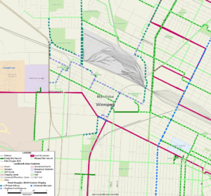 A new connection along Keewatin Street is currently being developed. In 2018, the pathway along Keewatin Street/Dr. Jose Rizal Way was extended south to Burrows Avenue. Plans for extension of the Keewatin Pathway south through the Keewatin Underpass to Gallagher Ave. will be developed in a functional design study scheduled for 2019. Construction is currently scheduled for 2021 at the same time as a planned road renewal project on Keewatin Street between Selkirk Avenue and Logan Avenue. A neighbourhood greenway along Gallagher Ave, Dee St, Pacific Ave., and Oddy St. would provide connections from the southern end of the pathway at Gallagher Ave. to Red River College’s Notre Dame Campus. The Gallagher-Dee-Pacific-Oddy Neighbourhood Greenway is identified in the Pedestrian and Cycling Strategies.
Completing the Alexander-Pacific-Elgin Neighbourhood Greenway
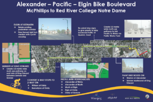
Many of the planned improvements for the Alexander-Pacific-Elgin Neighbourhood Greenway connecting to Red River College have never been completed.
Keewatin Street Crossing
Crossing of Keewatin Street along the Alexander-Pacific-Elgin Neighbourhood Greenway is currently aided by a pedestrian corridor, but unfortunately development of the greenway back in 2009.2010 did not include a way for someone on a bike to activate that pedestrian corridor (you have to get up onto the Notre Dame sidewalk to reach the crosswalk – which is offset by a fair bit on the east side of Keewatin Street- and activate the signal). This intersection crossing could be vastly improved through the installation of cyclist activated push buttons on Elgin Ave for activation of the pedestrian corridor and signage requiring northbound drivers on Keewatin Street to stop prior to Elgin Ave. when the pedestrian corridor is activated.
We are asking candidates in Point Douglas, St. James, and Daniel McIntyre to commit to including improvements to the Elgin AVe/Keewatin Street crossing in the Keewatin Street Pathway – Burrows to Gallagher Ave W Functional Design Study and any subsequent construction projects.
Plan & Construct the Gallagher-Dee-Pacific-Oddy Neighbourhood Greenway
Completion of the Keewatin Street Pathway through the Keewatin Street Underpass to Gallagher Ave W. will remove a major barrier for people wishing to bike to the Notre Dame Campus from the city’s northwest. The planned Gallagher-Dee-Pacific-Oddy Neighbourhood Greenway will act as the obvious connection between the two, but it’s planning and development is not currently included in the city’s Pedestrian and Cycling Program plans. We are asking all candidates in Point Douglas and Old Kildonan to commit to the planning of the Gallagher-Dee-Pacific-Oddy Neighbourhood Greenway in the Keewatin Street Pathway – Burrows to Gallagher Ave W Functional Design Study, currently scheduled for 2019. We would also ask that candidates commit to including construction of the Gallagher-Dee-Pacific-Oddy Neighbourhood Greenway in plans for the road renewal project on Keewatin Street between Selkirk Avenue and Logan Avenue scheduled for 2021.Improve Connections into RRC from the Sherwin Rd Pathway
The Sherwin Road Pathway makes use of a Pedestrian Corridor to facilitate crossings at Notre Dame Avenue, but the Pedestrian Corridor is located across the street from the pathway, which is on the west side of Sherwin Rd). Shared use pathways on Notre Dame provide a connection from Sherwin Rd to Dalton Crescent, but the connection is one way, and as it necessitates a crossing of Sherwin Rd. to cross Notre Dame Avenue, its a bit awkward. We are asking candidates to commit to a long term plan to provide connections from Sherwin Rd to:- Lismore Ave and the Alexander-Pacific-Elgin Neighbourhood Greenway
- Bannister Rd
- King Edward Street at Logan Avenue as a connection to the King Edward Street Pathway.
Planning for Future Connections to the King Edward Underpass & Bikeway
The bicycle network laid out in the 2015 Pedestrian and Cycling Strategies shows a local bikeway along King Edward Street beginning at Manitoba Ave. and running north to Jefferson Ave where it would connect to pathways planned along Jefferson and the planned extension of the Chief Peguis Trail. While the planned bike network does not include a connection through the King Edward Street Underpass, given that Keewatin Street and its pathway are 800m east of King Edward St, it seems obvious that this connection will eventually be needed. The 800m gap between King Edward and Keewatin Streets exceeds the maximum recommended distance between cycling facilities outside of the downtown (see page 135 of the Pedestrian and Cycling Strategies), so an extension of the King Edward Street Pathway south through the King Edward Street Underpass fits in with the strategies key directions 1B.i, 1B.vi, and 1B.xi of the Pedestrian and Cycling Strategies. Extending the King Edward St Pathway south to Alexander would provide direct access between:- Jefferson, Chief Peguis, and Sherwin Rd Pathways
- Red River College Notre Dame Campus
- Edon Ross Pool
- Brooklands School
- Woodsworth Park
- Tyndall Park Community Centre
- Tyndall Park Community School
- Brooklands, Tyndall Park, Garden Grove, Meadows West, Inkster Gardens, Waterford Green, Castlebury Meadows Neighbourhoods
- Formally adopt an extension of the King Edward Street Pathway south from Manitoba Avenue to Alexander Avenue in the city’s planned Bicycle Network.
- Formally adopt an extension of the King Edward Street Pathway west to the Keewatin Street Pathway through Woodsworth Park and Park lane in the city’s planned Bicycle Network.
Summary of Requested Candidate Commitments
- Include Planning for the Alexander-Pacific-Elgin and Gallagher-Dee-Pacific-Oddy Neighbourhood Greenways in the 2019 Keewatin Street Pathway – Burrows to Gallagher Ave W Functional Design Study.
- Commit to including improvements to the Elgin AVe/Keewatin Street crossing in the Keewatin Street Pathway – Burrows to Gallagher Ave W Functional Design Study and any subsequent construction projects.
- Commit to a long term plan to provide connections from Sherwin Rd to:
- Lismore Ave and the Alexander-Pacific-Elgin Neighbourhood Greenway
- Bannister Rd
- King Edward Street at Logan Avenue as a connection to the King Edward Street Pathway.
- Formally adopt an extension of the King Edward Street Pathway south from Manitoba Avenue to Alexander Avenue in the city’s planned Bicycle Network.
- Formally adopt an extension of the King Edward Street Pathway west to the Keewatin Street Pathway through Woodsworth Park and Park lane in the city’s planned Bicycle Network.
- 2009 Alexander-Pacific-Elgin Neighbourhood Greenway Plans (pdf)
- Keewatin Street Pathway (City of Winnipeg)
- Bike Winnipeg Backgrounder on Keewatin Street Pathway
- Empress Street Overpass Rehab & Reconstruction (City of Winnipeg)
- 2018 Pedestrian and Cycling Program Action Plan (City of Winnipeg)
A pathway along the east side of Empress Street will be built in 2019 as part of the Empress Street and Overpass Reconstruction and Rehabilitation Project, extending from St. Matthews Avenue in the north south over the Empress Street Overpass to the North Assiniboine Parkway. Future plans call for the pathway to be extended north all the way to Saskatchewan Avenue, where it will connect to pathways along Saskatchewan Avenue and Sherwin Road to provide a connection to Red River College’s Notre Dame Campus.
What’s missing from the planning to date is a way to connect from this planned Empress Street pathway north to the Alexander-Pacific-Elgin Neigbhourhood Greenway and the Northwest Hydro Corridor Greenway, and northwest towards the Keewatin Street Pathway. Work to extend the Keewatin Pathway south to Gallagher Avenue is scheduled to take place in 2019 (see our recommendations and rationale to include a path on the east side of Keewatin along with the planned pathway on the west side of Keewatin). Work on the Northwest Hydro Corridor Greenway should begin in 2019 (although an extension across the CPR Mainline may need to wait for a rehabilitation of the McPhillips Street Underpass).
An All Ages & Abilities Connection from Empress St to Alexander Ave
An all ages and abilities connection from Empress St to Alexander Avenue is possible using a mix of neighbourhood greenways along low volume residential streets in the Weston Neighbourhood, pathways along Saksatchewan Ave, Midland St, and the BNSF rail line, and a short two way protected bike lane segment along Notre Dame Ave between Dublin Ave and Spruce St. If implemented, the route would provide users with safe crossings of Notre Dame Ave, Weston St., McPhillips St, and Logan Ave at existing traffic signals or pedestrian corridors. Assuming future plans to extend the Northwest Hydro Corridor will include a safe crossing of Logan Ave, only the Elgin @ Keewatin crossing would require crossing improvements (push-button activation for the pedestrian corridor for people on bikes).
Replacement of the Omand’s Creek Bridge on Saskatchewan Ave in 2016 included provision for cycling facilities on Empress Street and a 2.5m wide sidewalk across Omand’s Creek that could accommodate a shared use pathway connecting Empress Street to a potential pathway along Saskatchewan Avenue leading to a Midland St pathway.
Include Connections to Alexander Ave in Planning for Empress St Pathway
We are asking that preliminary design of our proposed connections from the intersection of Empress St and Saskatchewan Ave to the intersection of Alexander Ave with Weston St, Lincoln and Pacific Avenues with Weston St, and improvements to the crossing of Keewatin St at Elgin Ave be added to the scope of the Preliminary Design Project for Rehabilitation of Empress Street between Saskatchewan Ave and St. Mathews Ave (set for 2023).
As there are no existing plans in the Pedestrian and Cycling Strategies for a crossing of the BNSF line to connect to planned Wellington Avenue Protected Bike Lanes (which serve as a spine in the bicycle network and connect through to Cumberland Avenue and the Downtown Protected Bike Lanes Network), we are also recommending that planning for the Empress St Pathway include a connection to the planned Clifton Neighbourhood Greenway via Notre Dame Ave and Spruce St.
More Information
Ward Boundaries: Legal Description Map
