Extending and improving the cycling facilities along St. Mathews Avenue would create the type of high quality cycling route that would serve as a central spine in the city’s cycling network.
Assiniboine Golf Club to Ferry Road
Starting from the northeast corner of the Assiboine Golf Club where the Yellow Ribbon Trail bends south to connect with Silver Avenue, a new pathway would be built along the northern boundary of the St. James Gardens and Memorial Sports Park to create a more pleasing and direct connection to the intersection of St. Mathews and Ferry Road.
Ferry Road to Century
Between Ferry Road and Century, parking would be removed along St. Mathews to allow for the installation of buffered bicycle lanes. In the few areas where there is strong demand for on street parking, parking bays would be built to retain parking.
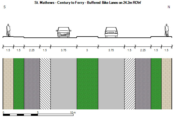
Buffered bike lanes on St. Mathews between Century and Ferry
Parking can be added where merited by demand
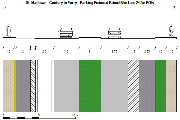
Century to Empress
The stretch of St. Mathews between Century and Empress will be rebuilt as part of the City of Winnipeg’s Polo Park Area Infrastructure Improvements Project. As part of that project, a new section of St. Mathews will be built between St. James and Madison. To improve cycling along this stretch or road, bollard protected bicycle lanes will be added to St. Mathews between Century and Empress.
Empress to Arlington
While conventional bike lanes and sharrows were added this section of St. Mathews between Empress and Arlington in 2010 as part of the stimulus funding AT projects, the treatment chosen was far less desirable than the treatment presented during the public open houses, and has been seen as a failure by most cyclists. To provide a safe, convenient and comfortable riding experience, one lane of parking would be removed and this section of road would be rehabilitated to include protected bicycle lanes on either side of the road. As there is very low utilization of parking along this stretch of St. Mathews, removal of a single lane of parking will not have an effect on the the availability of on street parking.
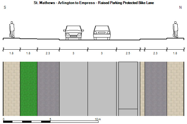
Protected Bike Lanes provide enhanced comfort for cyclists
Arlington to Maryland
Where the right of way on St. Mathews narrows between Arlington and Maryland, parking would be removed to make way for conventional painted bike lanes.
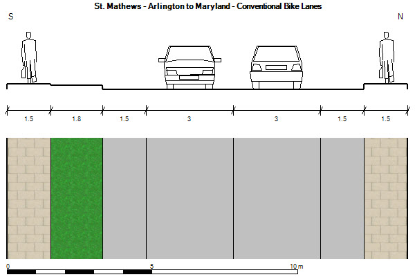
Conventional bike lanes would be painted between Arlington and Maryland
- Highlights:
- Adds conventional bike lanes between Maryland and Arlington
- requires removal of parking (side streets provide plenty of parking)
- Adds protected bike lanes between Arlington and Empress
- replaces substandard bike lanes and sharrows
- removes one lane of under utilized parking
- Adds protected bike lanes between Empress and Century
- part of the Polo Park Improvements Project that will connect St. Mathews between St. James and Madison
- Adds Protected Bike Lanes between Century and Ferry
- requires removal of parking lanes
- parking loss is mitigated by instillation of parking bays where demand merit
- Adds a new bike path along the northern border of St. James Memorial Sports Park
- Creates a more direct connection to the Yellow Ribbon Trail
- requires a new bridge over Truro Creek
- Traverses a well connected neighbourhood with a grid based road network
- Adds conventional bike lanes between Maryland and Arlington
- Connectivity
- Serves as an east/west spine in the city’s cycling network
- Connects the Yellow Ribbon Trail to the U of W
- see recommendations for U of W Connectivity Improvements
- Connects to existing and planned north/south bike routes
- Ferry Road
- Berry Road
- Empress Street
- Arlington Street
- Maryland/Sherbrook Street
- Estimated Cost: $3.75 million
St. Mathews Improvement and Extensions Project (in green)